Chloris Geospatial and Pond Foundation: empowering forest conservation through data, innovation, and love
We do what we do to accelerate the transition to a nature-positive future. We do it for the planet, the animals, the people. And so does Pond Foundation, with which we are thrilled to be partnering to support forest conservation efforts through science-based technology, data-driven solutions, and love for forests.
At the heart of this collaboration lies a shared vision: to harness the power of forests in combating climate change while empowering local communities to protect and heal their forests through innovation.
Pond Foundation is a Swiss non-profit that supports people and organizations to act in a regenerative way. It builds on the lifetime work of its CEO and Founder, Scott Poynton, of finding innovative ways to protect and better manage forests. The Foundation’s initiatives, particularly “My Carbon Zero” and “Forest Love”, support specific conservation projects by selling carbon removal credits to its member companies. But to do so, Pond Foundation needs to understand the on-ground situation with each potential forest project before agreeing to support it.
And this is where Chloris comes in.
Chloris Geospatial, a space technology company using Earth Observation data and machine-learning to produce natural capital data and insights, directly measures forest carbon stock, gains, and losses with quantified uncertainty at the pixel level, for any landscape, anywhere in the world, since the year 2000.
For communities managing forests, this means they can get accurate information on whether their forest is a carbon sink or a carbon source. If it’s a sink, Chloris’ analysis can reveal how many tonnes of CO2 have been sequestered by virtue of the community’s protection actions. It’s then possible to sell that carbon to organizations, like Pond Foundation My Carbon Zero members, who are driven to remove their annual or lifetime carbon balance from the atmosphere. The funds raised go to support ongoing forest protection actions and community livelihood development programs. If it’s a source, Chloris’ data can help communities to reframe forest management activities to return the forest to health.
The partnership between Pond Foundation and Chloris Geospatial is poised to unlock new possibilities in forest conservation and carbon removal initiatives, while upholding the highest standards of integrity, transparency, and respect for all projects and stakeholders involved.
Tanoe-Ehy Forest
Under the partnership, we’ve already analyzed seven different forest areas. One, Tanoe-Ehy, is in the Ivory Coast and is a partnership with the Forest Conservation Fund, a globally recognized Ivorian primatologist, Inza Koné, who is a 2023 Rolex Award Laureate, and 11 local communities who have joined the work to preserve their common heritage.
Tanoe-Ehy is one of the last remaining remnants of the once extensive Guinean forests of West Africa. The Guinean forests are recognized as a biodiversity hotspot as they’re one of the world’s critical primate conservation areas and are ranked among the world’s most important regions for mammalian diversity. Almost 85% of the original Guinean forests have been destroyed so Tanoe-Ehy represents a critical 10,000-hectare sanctuary in overall conservation efforts.
The forest continues to face pressures and the project aims to improve the conservation status of four of the most endangered primates in Africa, but the forest is rich in a beautiful array of other plant and animal species too. It contains at least 45 endemic – meaning they’re found nowhere else – plant and animal species.
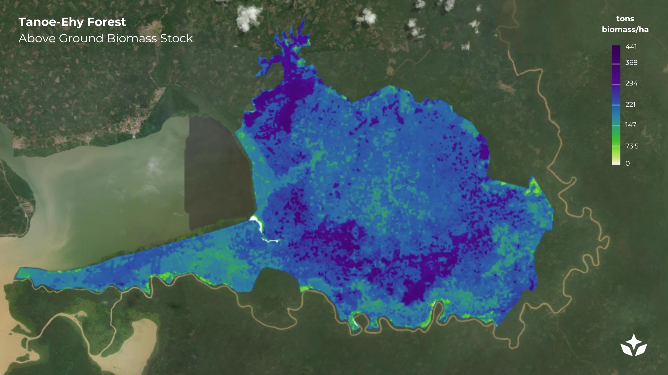
Chloris Platform - Tanoe-Ehy Forest 2022. Above Ground Biomass Stock map
Chloris’ analysis shows that the forest is a carbon sink and continues to sequester carbon from the atmosphere into the trees and plants living within it. Chloris’ data gives us robust estimates, delivered by Chloris' software, built upon best-in-class Earth Observation science, of how the forest biomass and carbon is changing over time. The analysis shows that the community protection program is working and that by at least one metric – growing biomass - the forest is in good health. We use the sequestration data as the basis for Pond Foundation members to support the community forest managers by purchasing Carbon Removal Credits. You can learn more about the project at Pond Foundation’s website.

Chloris Platform. Tanoe-Ehy Forest annual average density 2000-2022
About Chloris Geospatial
Chloris Geospatial is a technology company providing science-based forest carbon insights built with Earth Observation data, machine-learning and AI. Our mission is to accelerate the transition to net-zero and nature-positive societies with the most reliable, trustworthy, and transparent natural capital data. The Chloris Platform supports carbon market participants with cutting edge monitoring data for nature based projects, covering both removals and avoided emissions. From deforestation to forest degradation, growth, and regrowth of trees: Chloris sees what the atmosphere sees, for every pixel on the planet and since the year 2000.
About Pond Foundation
Pond Foundation is a Swiss-registered, global non-profit that inspires strong regenerative action for people and the planet. Its My Carbon Zero, Regen 21, Hilary’s Kids, Earthtrust and Forest Love initiatives break new ground in setting high standards for corporate and individual regenerative actions. It focuses on supporting communities, biodiversity, and the removal of carbon from the atmosphere.
For more information about Pond Foundation, please visit https://www.pond.foundation/ or contact Scott Poynton at scott@pond.foundation.